Modern Mobile Mapping That Also Works Offline

Improve your field services with Lemur.

Bring the power of geospatial technology to field workers. Lemur provides users zero-training access to your existing GIS. Staff can use geospatial workflows like redlining and as-builting to improve both field and back-office business processes.

Lemur is purpose built to work offline, so staff can perform remote duties regardless of cell coverage. By delivering an intuitive, robust geospatial toolset, Lemur reduces time wasted finding information, improves safety, and increases field efficiency.

Contact Us

Products_Modern-Mobile-Mapping-639x502-1

Put Enterprise-Grade Mobile Software to Work for You

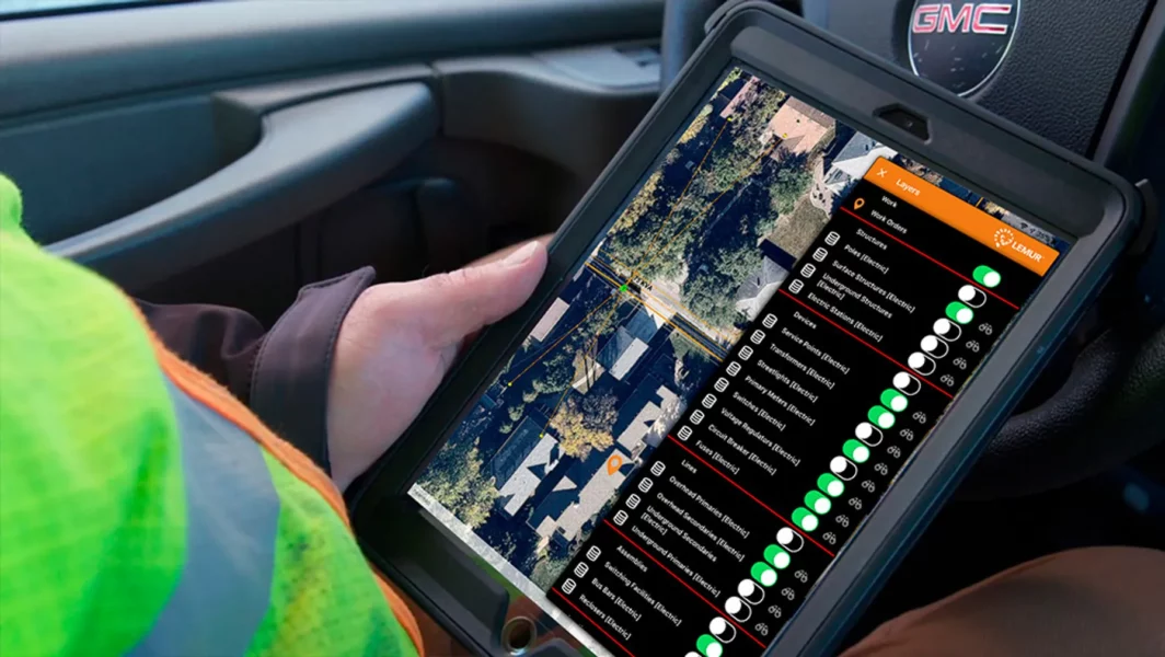
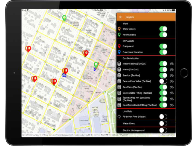
With Lemur, you add the benefits of powerful GIS tools to sophisticated work management, assignment, tracking, and other capabilities of your field service solution. Lemur complements your organization’s field service solution with world-class geospatial capabilities that no standalone field service app delivers. Lemur’s unique connectors to field service apps make field workflows powerful and intuitive.

Lemur supports a wide array of field operations, from vegetation management to asset maintenance and construction. It provides security that includes encrypted communication and authentication, as well as central control over access of critical infrastructure data.

Experience the Benefits of Lemur

Lemur can save 3-5% on field service costs by reducing overhead, errors and waste. Organizations can leverage the mobile GIS solution to:

  • Perform work in both online and offline environments
  • Accelerate construction to as-built in record time
  • Capture and correct data in the field
  • Reduce errors in performing and recording work
  • Ensure adoption and minimize training
GettyImages-2025408764

Why Lemur?

Whether you’re online or offline, experience all of these capabilities in a blazing fast map experience anywhere you work.

  • Locate correct assets quickly
  • Understand asset connectivity and interdependence
  • Look up asset characteristics
  • Record work and defect locations
  • Sketch, redline, markup and quickly create clear as-built drawings

Lemur – Modern Mobile Mapping

Discover the benefits of bringing GIS and other enterprise apps to the field and back office. TRC’s Lemur mobile mapping solution seamlessly delivers integrated, intuitive tools for work order management, asset management and more. Staff can easily collect data and document work in a safe, efficient and accurate manner.

Related Materials

Lemur Is Veracode Verified

Veracode Verified Standard represents that the following application security practices are embedded into the software development process:

  • Assessment of first-party code using static analysis
  • Documentation that the application does not allow Very High flaws in its first-party code
  • Developer access to remediation guidance Verified Standard is the first of three (3) tiers representing the Verified program

Learn more about the Veracode Verified program by clicking here.

Improve Your Field Services With Lemur
Mobile GIS

Maximize efficiency and minimize delays — mobile

Contact Us

Sharing Our Perspectives

Our practitioners share their insights and perspectives on the trends and challenges shaping the market.

Wind turbine, field and engineering man with renewable energy for countryside, sustainability and farming technology. Clean energy, sustainable and electricity windmill of person on tablet in sunset
Insights

Streamline Your Schedule, Dispatch and Field Execution with Lemur and Salesforce Field Service

February 27, 2025

Improve efficiency and data accuracy with intuitive, use-case specific tools and major platforms already in place

2-Long-Cycle
Insights

What is Long-Cycle Work and Why is Digitizing Important?

January 14, 2025

Long-cycle work typically refers includes large-scale projects like building new transmission lines, upgrading substations, or fortifying the existing grid.

Distribution-System-Ice-Storm-Damage-scaled-1
Insights

Why You Need Lemur Before the Next Disaster Strikes

October 3, 2024

Modern mobile mapping improves data accuracy and field mobility for utilities before, during and after events

Transmission-Towers-and-digital-nodes-scaled-1
Insights

Seven AI Use Cases That Deliver Value to Utilities

October 3, 2024

How Innovation Can Meet the Mandates of Safe, Clean and Reliable Energy at Affordable Prices

GettyImages-1418043934-752x502-1
Insights

Achieve Superior Asset Data Quality by Combining SAP with Lemur Mobile Mapping

September 23, 2024

Utilities struggle with asset data, which impacts every aspect of their business. Market priorities like grid modernization, decarbonization and increased energy demand only compound the problem of poor data quality.

GettyImages-1468396766
News

Locana will operate as TRC starting July 26, 2024

July 18, 2024

WINDSOR, Conn. (July 16, 2024)— In December 2023, Locana announced that it was acquired by TRC, a global leader providing environmentally focused and digitally powered solutions.

location-mapping
Insights

Optimize Your As-built Process with Lemur Mobile Mapping

June 4, 2024

This article was originally authored by Locana, which is now part of TRC. Replace paper and pencil with geospatial tools to transform field processes.

GettyImages-1464561797-scaled
Insights

Make Generative AI Your Business Data Advantage

May 23, 2024

This article was originally authored by Locana, which is now part of TRC. Connect to systems with geospatial tools and deliver chat and virtual assistant experiences for your employees and customers

Improve-Your-Enterprise-Data-Accuracy-with-Automated-Conflation-
Insights

Improve Your Enterprise Data Accuracy with Automated Conflation

May 8, 2024

Achieve superior speed and scale using AI combined with GIS.

Why-Integrated-GIS-and-EAM-Streamlines-and-Improves-Multiple-Workflows-
Insights

Why Integrated GIS and EAM Streamlines and Improves Multiple Workflows

May 1, 2024

Utilities can optimize construction and asset management using standardized designs and robust modeling.

Maximize-Your-Data-with-Machine
Insights

Maximize Your Data with Machine Learning, Computer Vision, and Location Technology

December 5, 2023

Companies can convert massive amounts of raw imagery into usable data that fuels multiple enterprise systems.

GettyImages-1200320986
News

Locana Awarded Modern Network Management at Esri Infrastructure Management and GIS Conference

November 22, 2023

Locana, an international leader in spatial technology, received the Modern Network Management Award at the 2023 Esri Infrastructure Management and GIS (IMGIS) Conference held in Palm Springs, California, October 10-12, 2023.

GettyImages-2167281802
Insights

Avoid the Point Solution Complexity Trap in Field Programs

November 21, 2023

Modern mobile mapping offers an enterprise approach that reduces complexity and risk.

Increase-Business-Performance-with-Data-Enrichment-
Insights

Increase Business Performance with Data Enrichment

October 30, 2023

Location-based solutions supply big business value to your operational data and applications.

Gain-a-Competitive-Advantage-with-Location-based-AI-940x393-1
Insights

Gain a Competitive Advantage with Location-based AI

October 18, 2023

Using AI can help transform business operations, and more, with data science services that deliver.

Implement-a-More-Efficient-GIS-ERP-Integration-Following-a-Few-Simple-Steps-
Insights

Implement a More Efficient GIS-ERP Integration Following a Few Simple Steps

October 6, 2023

Learn how to deploy faster and more efficiently using in-built SAP HANA platform capabilities.

GettyImages-1977085201
News

Esri Awards Locana with the ArcGIS Cloud Services Specialty Designation

October 4, 2023

Locana, an international leader in spatial technology, received Esri’s ArcGIS Cloud Services Specialty, which designates Locana as an expert in deploying and managing ArcGIS in cloud environments such as Amazon Web Services (AWS) and Microsoft Azure.

Modernize-Your-Field-Services-with-GIS-and-Work-Order-Management-Combined-
Insights

Modernize Your Field Services with GIS and Work Order Management Combined

June 15, 2023

The role of field service management continues to dominate the world economy, as the market grows at an exponential rate. The market was estimated at 3.2 billion in 2021 and is projected to reach 5.7 billion by the end of 2026.

GettyImages-2154872584
News

Locana Lemur Mobile GIS Solution Achieves Veracode Verified Standard Status

March 22, 2023

Locana, an international leader in spatial technology, today announced that on behalf of its Lemur Mobile GIS Solution, it participates in a secure software certification program from Veracode, a leading global provider of modern application security testing solutions.

Glean-Insight-from-Big-Data-
Insights

Harness the Power of Geospatial Data to Unlock Big Data Insights

March 16, 2023

For years, companies have been harnessing big data to glean insights that improve decision-making of every kind and at all levels, from entering new markets to building better products to delivering better services and experiences.

GettyImages-843961934
Insights

How to Bring Location Services to Your Company and Customers

March 9, 2023

TRC Companies can help you take advantage of Open Street data in a way that saves money while improving quality.

The-Rise-of-Data-as-a-Business-Problem-–-And-What-You-Can-Do-About-It-940x393-1
Insights

The Rise of Data as a Business Problem – And What You Can Do About It

August 17, 2022

Achieve better outcomes using a modern geospatial platform approach that connects systems and increases data accuracy.

The-Use-Case-Benefits-of-GIS-Modernization-for-Utilities-940x393-1
Insights

The Use Case Benefits of GIS Modernization for Utilities

August 10, 2022

GettyImages-182192687
News

Brookings Municipal Utilities Streamlines Processes, Boosts Efficiency with Modern GIS

June 14, 2022

Locana, a global leader in technology consulting and geospatial systems development, announced Brookings Municipal Utilities (BMU) successful deployment of a modern geospatial enterprise leveraging Locana services.

blogHero-OmahaMUD
News

Omaha Metropolitan Utilities District Drives Reliable Operations with Locana Lemur Mobile GIS Solution

June 8, 2022

Locana, a global leader in technology consulting and geospatial systems development, today announced the successful deployment of its LemurSM Solution by Omaha Metropolitan Utilities District (M.U.D.).

GettyImages-2170944745
Insights

Develop a Holistic View of Capital Projects Using Location

April 28, 2022

Discover how to improve decision-making, lower costs, and reduce risk using a map-based portal that integrates systems and data. Read more.

GettyImages-1267141573
News

Locana Awarded Wildlife Habitat Analysis Task Order For The Bureau Of Land Management

April 27, 2022

Locana, a leading geographic data and technology company, has won a 10-year National Geospatial Data and Technology Support Services contract for the U.S. Bureau of Land Management (BLM).

Combating-Climate-Change-with-the-Power-of-Location-
Insights

Combating Climate Change with the Power of Location

April 21, 2022

With climate change, geospatial solutions make sense of vast volumes of data for greater clarity and decision making. Read to learn more.

GettyImages-1337105602
Insights

The Business Value of Modern GIS for Utilities

November 18, 2021

The utility industry is under tremendous transformation, and more companies are working toward a clean energy future.